Located in the Southeast United States, Alabama is bordered to the north by Tennessee, to the south by Florida
and the Gulf of Mexico, to the west by Mississippi, and to the east by Georgia.
Alabama's land area covers approximately 50,744 square miles. The land is mostly rolling plains, except for the northeast part of
the state. This mountainous region is the southern end of the Cumberland Plateau. From these
uplands, the land slopes gently southward to the Mobile River delta.
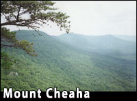 Mt. Cheaha is located in Cheaha State Park (Alabama's oldest state park), and is surrounded by the
Talladega National Forest. Of the mountains in Alabama, Mt. Cheaha has the distinction
of being the highest point in the state. In fact, the local Creek indians named it
"Chaha", which means high place. At its highest point, Mt. Cheaha stands
2,407 feet above sea level. Mt. Cheaha is located in Cheaha State Park (Alabama's oldest state park), and is surrounded by the
Talladega National Forest. Of the mountains in Alabama, Mt. Cheaha has the distinction
of being the highest point in the state. In fact, the local Creek indians named it
"Chaha", which means high place. At its highest point, Mt. Cheaha stands
2,407 feet above sea level.
Most of Alabama's waterways flow south to the Gulf of Mexico. Western Alabama is drained by the Tombigbee and
Black Warrior Rivers. The Alabama, Coosa, and Tallapoosa Rivers can be found in eastern and central
Alabama. The Mobile River is formed by the merging of the Alabama and Tombigbee Rivers just north of
Mobile. Southeast Alabama is home to three main rivers: the Chattahoochee, Choctawhatchee, and the Conecuh.
The Tennessee River flows southwest through east Tennessee, then loops through northern Alabama.
The Tennessee forms a small part of the state's border with Mississippi.
Alabama has no large natural lakes, but has many large man-made reservoirs. The largest of these is
Lake Guntersville. Construction of this reservoir began in December of 1935. It began filling
with water in January of 1939 and took more than four years to complete. Fishing is excellent on the
lake. Although two-thirds of anglers report fishing for largemouth bass, many also target bream, crappie, sauger,
and catfish. Lake Guntersville is located on the Tennessee River in Marshall County, Alabama.
Alabama's coastline is relatively short when compared to that of Florida or Mississippi.
It is 53 miles across the coast from the border of Mississippi to the border of Florida.
Mobile Bay can also be found on the coast of Alabama. Mobile Bay is the birthplace of Mardi Gras in
the United States. Despite the short coastline, Alabama has large, beautiful white beaches.
Alabama beaches, like those in the Gulf Shores area, are popular vacation spots.
|